Euratlas Home>
Euratlas Info>
Europe Countries
Become a member and get access to larger photos by subscribing to Euratlas-Info.
About
Privacy
Site Map
Contact
World Maps, Blank or Labelled
Historical Maps
History of Europe
Middle East History
Roma
World History
Geography Maps
Europe Atlas
World Atlas
Antique Maps
Antique Cartography
Lesage Atlas 1808
Peutinger Map
Europe Photos
Countries of Europe
Time Pictures
Euratlas
Shop
Member's Area
Euratlas Info
Antique Maps
Back Issues
Countries of Europe
Euratlas Games
Europe Maps
History Maps
Pictures of Europe
World Maps
Planisphère Blk Col.
Planisphère Blk Grey
Planisphère Lab. Col.
Planisphère Lab. Grey
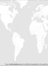
World Map Blk Col.
World Map Blk Grey
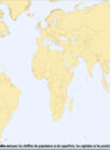
World Map Lab. Col.
World Map Lab. Grey
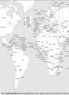
World Map Lab. Col.
World Map Lab. Grey
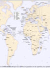
World Map Blk Col.
World Map Blk Grey
Planisphère Lab. Col.
Planisphère Lab. Grey
Planisphère Blk Grey
Planisphère Blk Col.
Euratlas-Info is free
You can download all the maps and pictures in the Euratlas-Info section. When you choose a map or image, click on it to display its high-resolution version.
Conditions of Use
Privacy Notice
Contact
Euratlas - 2001-2012